When you think of extraordinary natural wonders, few can match the raw power and mesmerizing beauty of Kilauea Volcano, one of the world’s most active volcanoes. Located on Hawaii’s Big Island, this geological marvel has been continuously reshaping the landscape, creating new earth, and inspiring awe in visitors and scientists alike for centuries.
Kilauea isn’t just any volcano—it’s a living laboratory where nature’s most powerful forces are on display. With its glowing molten lava, dramatic eruptions, and cultural significance to the Hawaiian people, Kilauea offers a glimpse into both the creative and destructive powers of our planet.
In this comprehensive guide, we’ll journey through Kilauea’s fiery history, explore its fascinating features, and discover why this volcano continues to captivate the imagination of travelers, scientists, and nature enthusiasts from around the world.
The Birth and History of Kilauea Volcano

Origins and Formation
The story of Kilauea Volcano begins deep beneath the Pacific Ocean, where it originated between 300,000-600,000 years ago as a submarine volcano. Born from the Hawaiian hotspot—a plume of magma rising from deep within Earth’s mantle—Kilauea is just one expression of this powerful geological phenomenon that created the entire Hawaiian-Emperor seamount chain.
Approximately 50,000-100,000 years ago, Kilauea emerged from the sea, gradually building itself up through countless eruptions. Unlike the explosive stratovolcanoes found along tectonic plate boundaries, Kilauea formed as a shield volcano, characterized by its broad, gently sloping profile built from relatively fluid lava flows.
“Kilauea ranks among the world’s most active volcanoes, with 90% of its surface covered by lava flows less than 1,000 years old,” notes the Hawaiian Volcano Observatory, highlighting the volcano’s remarkably dynamic nature.
Geological Evolution
While Kilauea appears as a mere bulge on the southeastern flank of the massive Mauna Loa volcano, research has revealed that Kilauea has its own distinct magma-plumbing system extending more than 60 kilometers (37 miles) deep into Earth’s mantle. This discovery helped scientists understand that despite their proximity, Kilauea and Mauna Loa are separate volcanoes with individual personalities and eruption patterns.
Over thousands of years, Kilauea’s summit gradually collapsed inward, forming the impressive caldera we see today. Within this caldera lies Halema’uma’u crater, a pit crater that has been the center of much of Kilauea’s recent activity. The present-day Kilauea caldera formed around 1470 CE, following the end of the ‘Ailā’au eruption, when the magma chamber below emptied enough to cause the overlying rock to collapse.
Historical Eruptions and Documentation
Long before written records, Native Hawaiians preserved the extraordinary eruptive history of Kilauea through oral traditions, chants, and legends. These culturally significant accounts tell of Pele, the volcano goddess, and her fiery displays of power.
Western documentation of Kilauea began in 1823 when Reverend William Ellis became the first European to visit the summit and record his observations. His writings described an active lava lake within Halema’uma’u crater, beginning the scientific record of Kilauea’s activity that continues to this day.
Perhaps the most notorious historical eruption occurred in 1790, when a powerful explosive event sent scorching pyroclastic surges across the landscape, killing hundreds of Hawaiian warriors who were traveling near the summit. This event remains the deadliest volcanic disaster recorded in what is now the United States.
10 Fascinating Facts About Kilauea Volcano

1. The Most Active of the Active
Among Earth’s active volcanoes, Kilauea Volcano stands out for its persistence. Since 1952, Kilauea has erupted dozens of times, and from 1983 to 2018, it maintained a nearly continuous eruption for 35 years. This remarkable consistency has given scientists unprecedented opportunities to study volcanic processes in real-time.
2. The Meaning Behind the Name
The name “Kilauea” in Hawaiian translates to “spewing” or “much spreading,” a perfect description of the volcano’s eruptive character. This apt name reflects the Hawaiian people’s deep observational skills and connection to the natural environment, capturing the essence of the volcano’s behavior in a single word.
3. A Volcanic Laboratory
Since 1912, the Hawaiian Volcano Observatory (HVO) has monitored Kilauea, making it one of the longest continuously observed volcanoes in the world. This scientific outpost, perched on the rim of Kilauea’s caldera, has pioneered many volcano monitoring techniques, advancing our understanding of these powerful natural phenomena.
4. Two Types of Lava
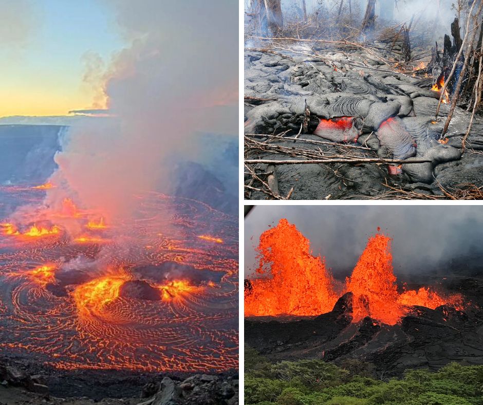
Visitors to Kilauea can witness two distinct types of lava flows: pāhoehoe (pronounced “pah-hoy-hoy”) and ‘a’ā (pronounced “ah-ah”). Pāhoehoe lava has a smooth, ropy appearance as it cools, while ‘a’ā lava forms jagged, rough surfaces. The difference primarily comes from flow viscosity, temperature, and rate of movement.
5. Pele’s Home
In Hawaiian tradition, Kilauea is the sacred dwelling place of Pele, the goddess of fire and volcanoes. Legend says that Pele traveled from island to island, creating each one with her volcanic power, before finally making her home in Kilauea’s Halema’uma’u crater. Even today, many Native Hawaiians leave offerings of flowers, food, and gin at the crater’s edge to honor and appease the goddess.
6. Record-Breaking Eruption
The Pu’u’ō’ō eruption that began in 1983 and ended in 2018 ranks as one of the longest-lasting continuous volcanic eruptions in recorded history. Over its 35-year duration, this event produced approximately 4.4 cubic kilometers (1.1 cubic miles) of lava, covered 144 square kilometers (55.6 square miles) of land, and added 177 hectares (439 acres) of new land to Hawaii’s southeastern shore.
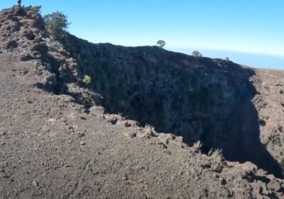
7. Crater Within a Crater
Kilauea’s structure features a crater within a crater. The main summit caldera spans approximately 3.5 km by 3 km (2.2 by 1.9 miles), while within it lies Halema’uma’u crater, a more active vent that has historically contained a lava lake. This nested crater system allows scientists to monitor changes that indicate deeper volcanic processes.
8. Land Creation in Action
One of Kilauea’s most remarkable features is its ability to create new land. When lava flows reach the ocean, they cool rapidly against the water, forming new rock that extends Hawaii’s coastline. Throughout history, Kilauea has added hundreds of acres to the Big Island, demonstrating the continuous process of island-building that created the Hawaiian archipelago.
9. Volcanic Landscapes and Ecosystems
Kilauea’s eruptive activity creates a natural laboratory for ecological succession. As lava flows cool and weather, they gradually develop into habitable land. Pioneer species like ferns and ʻōhiʻa lehua trees are among the first to colonize fresh lava, beginning a succession process that eventually leads to diverse forest ecosystems unique to Hawaii.
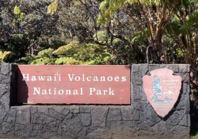
10. A National Park Treasure
In 1916, Kilauea became part of Hawaii Volcanoes National Park, protecting this natural wonder for future generations. In 1987, UNESCO recognized the park as a World Heritage Site for its outstanding geological and ecological significance. Today, the park attracts over 1.5 million visitors annually who come to witness the volcano’s dramatic landscapes and active eruptions.
Fun Facts About Kilauea for Kids
Volcano Vocabulary Made Easy
Volcanoes have their own special language! A caldera is like a giant bowl at the top of a volcano, formed when the ground collapses after an eruption. Lava is melted rock that flows on the surface, while magma is what we call that same melted rock when it’s still underground. Think of it like this: magma is like hot chocolate inside a pot, and lava is what happens when you pour it out!
Kilauea’s Quirky Features
Kilauea Volcano has some really cool features that seem magical! Lava tubes are like secret underground tunnels formed when the outside of a lava flow cools while the inside keeps flowing. When the lava drains out, it leaves behind a cave-like tunnel.
Have you ever heard of Pele’s hair? These are thin strands of volcanic glass that form when bits of lava are stretched by the wind as they’re thrown through the air. They look just like strands of hair from the volcano goddess Pele!
Volcano Safety Heroes
Scientists called volcanologists study Kilauea to keep people safe. They use special tools like seismometers to measure earthquakes, gas sensors to check the air, and even drones to look inside dangerous crater areas. These volcano scientists are like detectives, looking for clues about when and where the volcano might erupt next.
Make Your Own Volcano
You can create your own volcano at home! Mix vinegar and baking soda inside a model volcano (made from clay or paper mache) to create a fizzy eruption. While your homemade volcano works because of a chemical reaction, real volcanoes like Kilauea erupt because of pressure and heat deep underground that force molten rock to the surface.
Kilauea's Physical Characteristics

How Deep is Kilauea Volcano?
The depth of Kilauea’s caldera reveals the massive scale of this volcanic system. The summit caldera measures approximately 3.5 kilometers by 3 kilometers (2.2 by 1.9 miles) across, with a depth of about 600 meters (1,970 feet) at its deepest point. This impressive depression was even deeper historically, but has gradually filled with lava flows over time.
More astonishing is what lies beneath: Kilauea’s magma chamber extends more than 60 kilometers (37 miles) below the surface, connecting to the mantle source that fuels Hawaii’s volcanic activity. This extensive underground plumbing system explains Kilauea’s persistent and prolific eruptions.
During the dramatic 2018 eruption and collapse event, the dimensions of Halema’uma’u crater changed significantly, expanding from about 1 kilometer in diameter to roughly 2.5 kilometers, and deepening by more than 500 meters (1,600 feet). This single event moved approximately 0.8 cubic kilometers (0.2 cubic miles) of material.
Structure and Features
Kilauea’s structure follows the classic shield volcano form, with gently sloping sides and a broad profile built by fluid lava flows. What makes Kilauea particularly interesting are its rift zones—areas of weakness in the volcano’s structure where magma can intrude and erupt from fissures.
The East Rift Zone and Southwest Rift Zone extend from Kilauea’s summit like arms, creating linear pathways where eruptions frequently occur. These rift zones are marked by pit craters, cinder cones, and fissures that have formed during past eruptions.
Beyond Halema’uma’u crater, Kilauea features numerous other volcanic landmarks, including:
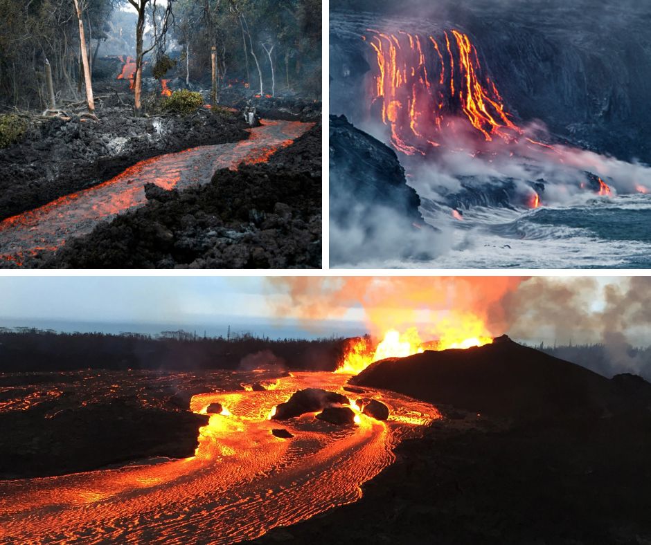
- Thurston Lava Tube (Nāhuku): A 500-year-old lava tube that visitors can walk through
- Steam vents: Areas where groundwater is heated by the volcanic system, creating impressive steam plumes
- Sulphur banks: Mineral deposits where volcanic gases have interacted with surface rocks
- Kīlauea Iki: A pit crater that held a lava lake during the spectacular 1959 eruption
The volcano’s elevation reaches 1,247 meters (4,091 feet) above sea level at its highest point, though its true height is much greater when measured from its submarine base.
Kilauea's Destructive and Creative Power

Historical Damage Assessment
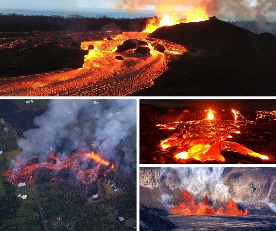
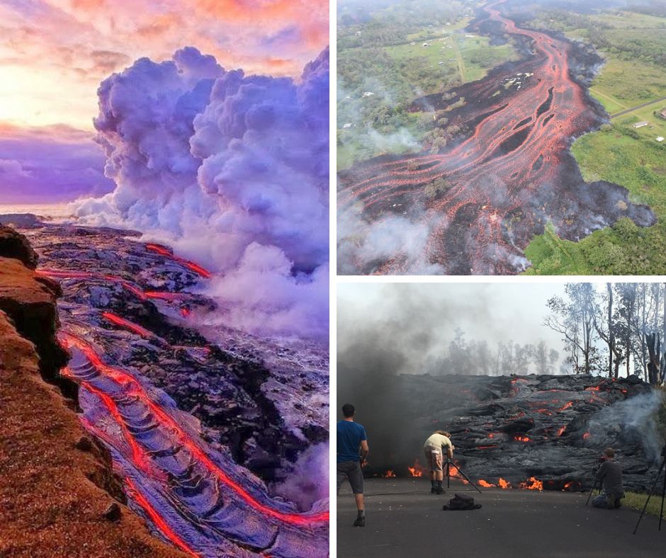
Throughout recorded history, Kilauea’s eruptions have repeatedly impacted communities and infrastructure on the Big Island. The village of Kalapana provides one of the most poignant examples. During the Pu’u’ō’ō eruption’s most destructive phase in 1990, lava flows buried this historic Hawaiian community, destroying 100 homes, a church, a store, and the famous black sand beach at Kaimu under 15-25 meters (50-80 feet) of lava.
Over time, Kilauea has severed highways, disrupted utility services, and rendered vast tracts of agricultural land unusable. Hawaii’s Chain of Craters Road has been repeatedly covered by lava flows, with sections repeatedly rebuilt only to be buried again, demonstrating the ongoing challenge of maintaining infrastructure in this dynamic volcanic landscape.
The Devastating 2018 Eruption
The 2018 eruption stands as one of Kilauea’s most destructive events in modern times. Beginning in May 2018, the volcano underwent a dramatic transformation when the long-lived Pu’u’ō’ō vent collapsed and activity shifted to the Lower East Rift Zone.
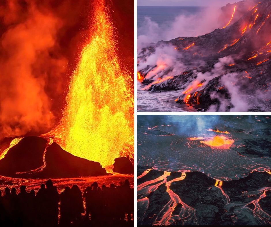
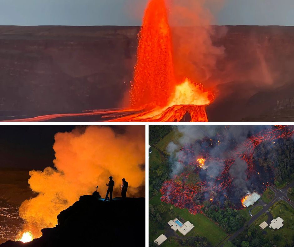
Over four months, 24 fissures opened in and near the Leilani Estates and Lanipuna Gardens subdivisions, with “Fissure 8” (later named Ahuʻailāʻau) becoming the dominant vent. Lava fountains reached heights of over 150 meters (500 feet), feeding fast-moving flows that reached the ocean, creating a toxic plume of “laze” (lava haze).
The human toll was tremendous:
- Over 700 homes destroyed
- Approximately 3,000 residents displaced
- $236.5 million in damage to public infrastructure
- $27.9 million in agricultural losses
- Entire communities like Kapoho Bay completely erased from the map
Simultaneously, Kilauea’s summit underwent catastrophic change as the magma drained from beneath Halema’uma’u crater, causing the caldera floor to collapse more than 500 meters (1,600 feet). This collapse triggered thousands of earthquakes, including a magnitude 6.9 that was Hawaii’s largest in decades.
Environmental Impacts
Kilauea’s eruptions create significant environmental impacts beyond property destruction. Volcanic emissions, particularly sulfur dioxide gas, combine with atmospheric moisture to create “vog” (volcanic smog) that can cause respiratory issues and damage vegetation miles from the eruption site.
When lava enters the ocean, it creates dramatic new coastlines but also destroys marine ecosystems. The 2018 eruption filled in Kapoho Bay, once a vibrant coral reef ecosystem and popular snorkeling spot, completely altering the coastal environment.
However, volcanic activity also brings environmental benefits. The weathering of volcanic soil eventually creates some of the most fertile land on Earth, supporting Hawaii’s lush vegetation. Nutrients from volcanic ash enrich surrounding waters, potentially boosting marine productivity in the long term.
The Phoenix Story: Recovery and Regrowth
Nature’s resilience is perhaps most visible on Kilauea’s slopes, where life returns to barren lava fields with remarkable persistence. Pioneer species like the ‘ōhi’a lehua tree can establish themselves on fresh lava within a few years, their bright red flowers forming striking contrasts against the black volcanic rock.
Human communities have shown similar resilience. While some residents displaced by eruptions have relocated, others have rebuilt, adapting to life with an active volcano. New opportunities emerge from the destruction—some former residential areas have become popular visitor sites where people come to witness the power of nature and the process of recovery.
Kilauea reminds us that destruction and creation are two sides of the same natural process—what appears devastated today will transform into new landscapes and ecosystems tomorrow.
Cultural Significance of Kilauea
How Kilauea Got Its Name
The name “Kilauea” perfectly embodies the volcano’s character. Derived from the Hawaiian language, it translates to “spewing” or “much spreading,” aptly describing the volcano’s frequent and extensive lava flows. This descriptive name reflects the deep observational connection Native Hawaiians maintained with the natural environment.
In Hawaiian culture, place names carry significant meaning, often describing a location’s physical attributes or commemorating important events. Kilauea’s name represents not just a geographical label but an acknowledgment of the volcano’s fundamental nature and behavior.
Pele: The Goddess of Fire
Central to Kilauea’s cultural significance is its role as the dwelling place of Pele, the Hawaiian goddess of fire, lightning, wind, and volcanoes. According to legend, Pele traveled from island to island, creating each with her volcanic power before finally making her home in Kilauea’s Halema’uma’u crater.
Pele is considered both creative and destructive—a powerful deity whose moods manifest in volcanic activity. Traditional Hawaiian chants tell of her fierce battles with her sister Nāmakaokahaʻi, the goddess of the sea, representing the eternal struggle between volcanic fire and ocean water.
Even today, many Native Hawaiians maintain deep spiritual connections to Kilauea. Offerings of flowers, food, and gin (Pele’s favorite) are commonly left at the crater’s edge. During eruptions, some practitioners perform hula and chant oli (chants) to honor and appease the goddess.
Historical Connections
Archaeological evidence shows human settlement near Kilauea dating back several centuries. The volcano’s fertile slopes, despite the eruption hazards, provided valuable agricultural land and resources like volcanic glass for tools.
Throughout Hawaiian history, the volcano has influenced cultural practices, art, and spiritual beliefs. Petroglyphs (rock carvings) found in Hawaii Volcanoes National Park document the long relationship between Hawaiians and this dynamic landscape. Many traditional hula dances tell stories of Pele and the volcanic landscapes she created.
For visitors to Kilauea, understanding this cultural context enhances appreciation of the volcano beyond its geological significance. The cultural practices surrounding Kilauea remind us that this natural wonder is not just a scientific curiosity but a living spiritual entity deeply woven into Hawaiian cultural identity.
Experiencing Kilauea Today
Current Eruption Status
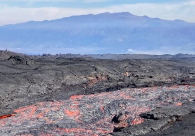
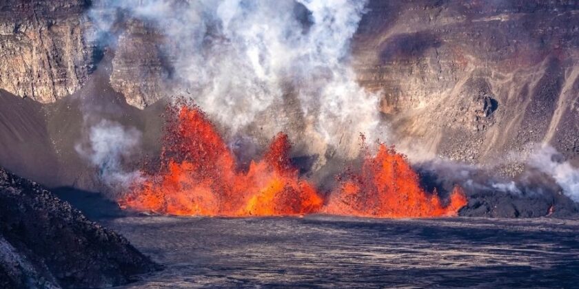
As of May 2025, Kilauea Volcano is experiencing an episodic eruption pattern that began in December 2024. This activity is centered within Halema’uma’u crater at the summit caldera. The current eruption features periodic lava fountaining episodes from vents on the crater floor, with pauses between episodes allowing the magma chamber to recharge.
According to the U.S. Geological Survey’s Hawaiian Volcano Observatory, these eruptive episodes typically last from several hours to over a week, with intervening pauses lasting between 24 hours and 12 days. During active periods, lava fountains can reach heights of over 150 meters (500 feet), creating spectacular nighttime viewing opportunities.
Scientists monitor various indicators to forecast upcoming eruptive episodes, including ground deformation, seismic activity, and gas emissions. This information is regularly updated through the USGS website and alert systems, helping visitors plan their volcano viewing experiences.
Visitor Experience and Viewing Opportunities
Hawaii Volcanoes National Park offers several excellent vantage points to witness Kilauea’s current activity safely. The best viewing locations include:
- Uēkahuna overlook (formerly Jaggar Museum area): Provides one of the closest views of Halema’uma’u crater, especially impressive at night when the lava’s glow illuminates the crater
- Kūpinaʻi Pali (Waldron Ledge): Offers a different perspective of the caldera with fewer crowds
- Keanakākoʻi overlook: When air quality permits, provides excellent views of eruptive activity
- Steam Vents parking area: Distant but accessible views of the summit caldera
Ranger-led programs enhance the visitor experience with expert interpretation of the volcanic activity and cultural significance. Evening programs are particularly popular, as darkness enhances the visibility of the incandescent lava.
Planning Your Visit
The Big Island is currently safe for travelers, with volcanic activity confined to the summit area within Hawaii Volcanoes National Park. Roads and facilities outside the immediate eruption zone remain open and accessible.
For optimal viewing of Kilauea’s eruptive activity:
- Best times: Dawn and dusk provide dramatic lighting conditions, while nighttime offers the most vivid views of the lava’s glow
- Weather considerations: Morning often has clearer visibility before clouds build up; winter months typically have clearer weather overall
- Essential items: Warm clothing (summit temperatures can drop to 50°F/10°C), sturdy footwear, flashlight for evening visits, binoculars, and camera with tripod for night photography
- Stay updated: Check the park’s official website or call the visitor center for the latest eruption updates and viewing recommendations
Most viewing areas are wheelchair accessible, with paved paths and established overlooks. The park continues to improve accessibility options for visitors with mobility challenges.
Beyond the Eruption: Other Park Highlights
While the active eruption attracts most visitors, Hawaii Volcanoes National Park offers numerous other fascinating experiences:
- Crater Rim Drive: A scenic route with stops at steam vents, sulfur banks, and stunning viewpoints
- Thurston Lava Tube (Nāhuku): Walk through a 500-year-old lava tube that once carried flowing lava
- Kīlauea Iki Trail: Hike across a solidified lava lake from the 1959 eruption
- Chain of Craters Road: Drive from summit to sea, passing numerous craters and ending at the coastline where lava flows have repeatedly covered the road
- Petroglyphs: Visit Pu’u Loa Petroglyphs, where over 23,000 ancient Hawaiian rock carvings can be viewed
- Kahuku Unit: Explore this less-visited section of the park with guided hikes through diverse volcanic landscapes
The Kilauea Visitor Center provides educational exhibits on the volcano’s geology, ecology, and cultural significance, serving as an excellent starting point for your exploration of this extraordinary natural wonder.
Kilauea's Most Notable Eruptions
The 1790 Explosive Eruption
The 1790 eruption stands as the deadliest volcanic disaster in what is now U.S. territory. Unlike Kilauea’s typically effusive eruptions, this event was explosively violent, sending searing pyroclastic surges across the landscape. These superheated clouds of gas, ash, and rock fragments swept down the volcano’s western flank, catching a contingent of Hawaiian warriors traveling near the summit.
Historical accounts vary on the exact death toll, with estimates ranging from 80 to several hundred fatalities. Archaeological evidence supports the event’s deadly impact—footprints preserved in ash deposits show where people desperately tried to flee the eruption.
Scientific research suggests this unusually explosive eruption resulted from groundwater interacting with the magma system, creating steam explosions. This event reminds us that while Kilauea Volcano typically produces relatively gentle lava flows, it is capable of more dangerous explosive behavior under certain conditions.
The Mauna Ulu Eruption (1969-1974)
Before Pu’u’ō’ō claimed the title of Kilauea’s longest historic eruption, the Mauna Ulu event held that distinction. For five years, this eruption on the East Rift Zone created spectacular displays, including lava fountains reaching heights of up to 540 meters (1,770 feet)—taller than the Empire State Building.
Mauna Ulu, meaning “growing mountain” in Hawaiian, lived up to its name by building a 121-meter (397-foot) tall lava shield. The eruption added approximately 230 acres (93 hectares) of new land to Hawaii’s shoreline and provided scientists unprecedented opportunities to study sustained eruptive processes.
This eruption became a scientific milestone, as it was the first time researchers could document a long-duration event from beginning to end with modern monitoring equipment. The observations made during this period significantly advanced volcanological understanding of Kilauea’s behavior.
The Record-Breaking Pu’u’ō’ō Eruption (1983-2018)
The Pu’u’ō’ō eruption rewrote the record books as Kilauea’s longest and most voluminous eruption in over 500 years. Beginning on January 3, 1983, this East Rift Zone eruption continued nearly continuously for 35 years until April 2018.
The eruption’s statistics are staggering:
- Produced approximately 4.4 cubic kilometers (1.1 cubic miles) of lava
- Covered 144 square kilometers (55.6 square miles) of land
- Added 177 hectares (439 acres) of new land to Hawaii’s coastline
- Destroyed 215 structures over its duration
- Buried 14.3 kilometers (8.9 miles) of highway
Scientists divided this marathon eruption into 61 distinct episodes, each with unique characteristics. The early years featured spectacular lava fountains up to 460 meters (1,500 feet) high from the Pu’u’ō’ō vent. Later, activity shifted to the Kupaianaha vent, which produced a stable lava lake and tube system that carried lava to the ocean.
This eruption transformed both the landscape and our scientific understanding of sustained volcanic activity, making it one of the most significant volcanic events in modern history.
The Transformative 2018 Eruption
The 2018 eruption marked the dramatic conclusion to the Pu’u’ō’ō era and represented Kilauea’s most destructive event in centuries. Unlike previous eruptions confined to less populated areas, this event directly impacted residential communities in Puna.
Beginning with the collapse of the Pu’u’ō’ō crater on April 30, 2018, magma migrated underground toward the Lower East Rift Zone. By May 3, the first fissures opened in Leilani Estates, eventually growing to 24 separate fissure vents. Fissure 8 (later named Ahuʻailāʻau) became the dominant vent, producing fountains over 150 meters (500 feet) high and feeding a river of lava that reached the ocean at Kapoho.
Simultaneously, as magma drained from beneath Kilauea’s summit, Halema’uma’u crater experienced catastrophic collapse. Over 60,000 earthquakes accompanied more than 60 collapse events, dramatically reshaping the summit caldera and destroying scientific infrastructure.
What made this eruption scientifically significant was its volume and intensity over a short period. The estimated 1.5 cubic kilometers (0.4 cubic miles) of lava erupted in just four months makes it one of the largest effusive eruptions worldwide in recent decades. The dramatic concurrent summit collapse provided unprecedented insights into the interconnected nature of Kilauea’s magmatic system.
Living with an Active Volcano
Monitoring and Warning Systems
The Hawaiian Volcano Observatory (HVO), operated by the U.S. Geological Survey, stands at the forefront of Kilauea Volcano monitoring. Established in 1912, HVO employs a comprehensive array of technologies to track volcanic activity:
- Seismic networks detect earthquakes that may signal magma movement
- Ground deformation instruments measure how the volcano’s surface inflates or deflates as magma moves beneath
- Gas monitoring tracks emissions of sulfur dioxide and other volcanic gases
- Webcams and thermal cameras provide visual monitoring of active vents
- Satellite data offers broad perspectives on ground deformation and thermal anomalies
This multi-faceted monitoring approach allows scientists to forecast eruptions with increasing accuracy. During the 2018 eruption, HVO’s warnings enabled authorities to evacuate residents before homes were destroyed by lava, preventing any fatalities despite the extensive property damage.
The Hawaii County Civil Defense Agency works closely with HVO to translate scientific data into public warnings. Their alert system uses sirens, emergency broadcasts, door-to-door notifications, and mobile phone alerts to keep residents informed about volcanic hazards.
Adapting to Volcanic Hazards
Communities near Kilauea Volcano have developed unique adaptations to life beside an active volcano. Building codes in volcanic hazard zones require specific structural elements to withstand earthquakes and ash fall. Some neighborhoods have designated evacuation routes and regular drills to prepare for eruptions.
Land use planning reflects the reality of volcanic hazards, with Hawaii County establishing Lava Flow Hazard Zones that influence development regulations. Insurance considerations are complex; standard homeowners’ policies generally don’t cover volcanic damage, requiring residents to seek specialized coverage through the Hawaii Property Insurance Association.
Perhaps most remarkable is the psychological adaptation of residents who choose to remain in high-risk areas. Many develop a philosophical outlook that balances appreciation for the island’s natural beauty with acceptance of its inherent risks. As one long-time resident expressed, “Living with Pele means understanding you don’t own the land—you’re just borrowing it for a while.”
Cultural Perspectives on Risk
Native Hawaiian perspectives on Kilauea’s eruptions often differ from Western risk assessment frameworks. Many Hawaiians view eruptions not simply as natural hazards but as manifestations of Pele’s will—a natural process that should be respected rather than feared.
Traditional knowledge complements modern scientific monitoring in interesting ways. Historical accounts preserved in chants and oral histories document past eruption patterns. Some cultural practitioners report being able to sense impending eruptions through subtle environmental changes or dreams—observations that sometimes align with scientific measurements.
This cultural understanding influences disaster response, with evacuation plans accounting for cultural sites and practices. During eruptions, cultural monitors work alongside emergency management teams to ensure that response activities respect sacred places and traditions.
The integration of scientific and cultural perspectives represents a holistic approach to living with Kilauea, acknowledging both the physical hazards and spiritual dimensions of this powerful volcano.
Final Thoughts
Kilauea Volcano stands as a testament to our planet’s dynamic nature—a place where Earth’s inner fire meets the surface in spectacular displays that both create and destroy. From its birth beneath the Pacific waves hundreds of thousands of years ago to today’s ongoing eruptions, Kilauea continues to shape Hawaii’s landscape and culture.
As we’ve explored throughout this journey, Kilauea Volcano is far more than just a geological feature. It’s a living laboratory that has advanced our understanding of volcanic processes. It’s a sacred place central to Hawaiian spiritual traditions. It’s a destroyer of homes and infrastructure, yet also a creator of new land. These seeming contradictions make Kilauea a perfect metaphor for nature itself—powerful, unpredictable, destructive, and creative in equal measure.
For those fortunate enough to witness Kilauea’s activity firsthand, the experience often transcends mere sightseeing. Standing at the crater’s edge as the earth glows red beneath a star-filled Hawaiian sky creates a profound connection to our planet’s raw power. The ancient Hawaiians understood this power intimately, personifying it as Pele and weaving the volcano into their cultural identity.
As Kilauea Volcano continues its fiery dance into the future, it reminds us of our place in Earth’s grand geological story. We are mere witnesses to processes that have shaped our planet for billions of years and will continue long after we’re gone. Yet in that humbling realization comes a special kind of wonder—the privilege of experiencing one of nature’s most extraordinary displays.
Whether you’re planning your first visit to this remarkable volcano or simply expanding your knowledge of Earth’s wonders, Kilauea Volcano offers endless fascination. Its story is still being written with each new eruption, each new lava flow, each new acre of land claimed from the sea. In the words of an old Hawaiian saying: “The land is the chief; man is its servant.” Nowhere is this truth more evident than on the ever-changing slopes of Kilauea.
Practical Information for Visitors
- Park Hours: Hawaii Volcanoes National Park is open 24 hours daily, year-round
- Entrance Fees: $30 per vehicle, valid for 7 days; America the Beautiful passes accepted
- Visitor Center Hours: 9:00 AM to 5:00 PM daily
- Best Time to Visit: May through October typically has the best weather
- Nearest Airports: Hilo International Airport (45 minutes) or Kona International Airport (2.5 hours)
- Accommodations: Volcano House hotel within the park, plus numerous vacation rentals and B&Bs in nearby Volcano Village
- Current Eruption Updates: Check https://www.nps.gov/havo or call (808) 985-6000 before your visit
Have you experienced Kilauea Volcano? Share your photos and stories in the comments below using #KilaueaWonder!